


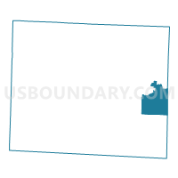
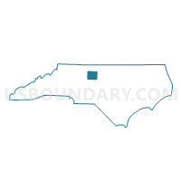
Voting District RC2, Guilford County, North Carolina
About
Outline

Summary
| Unique Area Identifier | 640231 |
| Name | Voting District RC2 |
| County | Guilford County |
| State | North Carolina |
| Area (square miles) | 19.95 |
| Land Area (square miles) | 19.68 |
| Water Area (square miles) | 0.27 |
| % of Land Area | 98.66 |
| % of Water Area | 1.34 |
| Latitude of the Internal Point | 36.04825080 |
| Longtitude of the Internal Point | -79.58144580 |
Maps

Graphs
Select a template below for downloading or customizing gragh for Voting District RC2, Guilford County, North Carolina


Neighbors
Neighoring Voting District (by Name) Neighboring Voting District on the Map
- Voting District 02, Alamance County, NC
- Voting District 03S, Alamance County, NC
- Voting District 03W, Alamance County, NC
- Voting District GIB, Guilford County, NC
- Voting District GR, Guilford County, NC
- Voting District JEF2, Guilford County, NC
- Voting District JEF4, Guilford County, NC
- Voting District NCLAY2, Guilford County, NC
- Voting District RC1, Guilford County, NC
Top 10 Neighboring County Subdivision (by Population) Neighboring County Subdivision on the Map
- Township 3, Boone Station, Alamance County, NC (25,227)
- Rock Creek township, Guilford County, NC (11,635)
- Jefferson township, Guilford County, NC (10,424)
- Clay township, Guilford County, NC (7,359)
- Township 2, Coble, Alamance County, NC (4,491)
- Greene township, Guilford County, NC (3,386)
Top 10 Neighboring Place (by Population) Neighboring Place on the Map
- Burlington city, NC (49,963)
- Gibsonville town, NC (6,410)
- Sedalia town, NC (623)
- Whitsett town, NC (590)
Top 10 Neighboring Unified School District (by Population) Neighboring Unified School District on the Map
Top 10 Neighboring State Legislative District Lower Chamber (by Population) Neighboring State Legislative District Lower Chamber on the Map
Top 10 Neighboring State Legislative District Upper Chamber (by Population) Neighboring State Legislative District Upper Chamber on the Map
Top 10 Neighboring 111th Congressional District (by Population) Neighboring 111th Congressional District on the Map
Top 10 Neighboring Census Tract (by Population) Neighboring Census Tract on the Map
- Census Tract 152, Guilford County, NC (8,412)
- Census Tract 153, Guilford County, NC (7,791)
- Census Tract 172, Guilford County, NC (6,919)
- Census Tract 217.03, Alamance County, NC (4,866)
- Census Tract 217.01, Alamance County, NC (3,237)